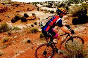
If you haven't already dusted off your bike and given it a tune-up (for tips, see Out There of March 31), do so now. Then head out on your favorite trail. The photo is from the recent trip Dave Philipps and photographer Christian Murdock took to Moab. (I'm posting while Dave's out and about - Dena.)
For a local ride, check out this Happy Trails feature from our archives. For more trails, see our Web site and check upcoming issues of Out There, which appears every Friday in The Gazette.
Pine Valley Ranch
Where: Part of the Jefferson County Open Space program, Pine Valley is near the town of Pine off Road 126.
To Get There: Take U.S. Highway 24 west to Woodland Park. Turn right on Colorado Highway 67. At Deckers, curve left on Road 126. Stay on 126 to the town of Pine, then turn left on Crystal Lake Road. Follow signs to Pine Valley Ranch Open Space.
Trip Log: ONE BOOT. Total distance hiked on three trails, about 5 miles: Narrow Gauge Trail, about 2 miles; Pike View Trail, about 1 mile; Buck Gulch, about 2 miles.
The Hike: This is part of Jefferson County Open Space, which means it’s well-marked and well-maintained with a huge parking lot. A total of 820 acres, it’s one of the county’s smaller properties, but hikers can explore about five miles of trails, and bikers can use one of them to hook up to other Forest Service Trails within the nearby Buffalo Creek Mountain Bike Area.We explored three trails within this park.
Narrow Gauge is the easiest, and on dry days would work for wheelchairs or strollers. Its surface is wide, flat and smooth, and it meanders along the shoreline of the North Fork of the South Platte River. Birds are plentiful, and on a sunny Sunday, eight snakes crossed the trail (six garters and two smooth green).
Buck Gulch is a trail that connects to other trails outside the Open Space boundary. It’s narrower, and favored by the bicyclists who love this park.
Park View is a single-track trail that’s for hikers only. It climbs through thick forest from the shore of picturesque Pine Lake to a rocky outcropping of broad granite boulders perfect for that afternoon nap. This trail is steep, with 300 steps installed on its steeper portions.
Information: This is a great park for non-hikers as well as hikers or bikers, with a stretch of wide, paved trail; handicapped-accessible fishing docks on the lake; bridges that cross the North Fork of the South Platte, and a public observatory that offers regular programs. Jefferson County Open Space, 1-303-271-5925.
Rathing System: A scale of one to four boots. One is easiest, with little elevation gain, and it is at a reasonable altitude. Four is most difficult, with severe elevation gain, difficult terrain or extreme length.
-Deb Acord, The Gazette
No comments:
Post a Comment